ARIZONA / ROUTE 66 |
| Home > Travel > USA > Arizona > Route 66 |
| In Arizona Route 66 follows Interstate 40 much of the way, with 2 exceptions. From Needles Route 66 goes through Oatman to Kingman (here I-40 takes a more southern route), and from Kingman to Seligman Route 66 goes trough Peach Springs instead of the more direct route the I-40 take. | ||
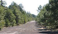
Aubrey Valley / Aubrey Cliffs |
||
| If you go east on Route 66 from Peach Springs to Seligman you will come to Aubrey Valley about 10 miles east of Peach Springs. Route 66 through Aubrey Valley is totally straigt for about 13 miles or so, and in the distance you can see the Aubrey Cliffs. Since my first trip on Route 66, this part has always fascinated me. | 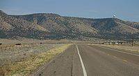
Aubrey Valley (140 kb) |
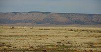
Aubrey Valley (156 kb) |
SeligmanSeligman is a very little town that today survives (?) on Route 66-tourism. The main street through town has several souvenirshophs.
|
||
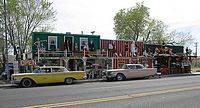
Seligman - Rusty Bolt and Thunderbird Trading Store (225 kb) |
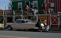
Seligman - Rusty Bolt and Thunderbird Trading Store (187 kb) |
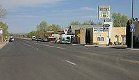
The main street in Seligman (137 kb) |
Ash Fork |
||
| Route 66 goes through Ash Fork - in the old days, with no interstate competing with Route 66, and with Santa Fe's transcontinental railroad going through town, Ash Fork was a more important town than today, where most traffic passes by on Interstate 40 and with the transcontinental railroad realigned several miles north (the railroad line between Williams and Phoenix still goes through Ash Fork). | 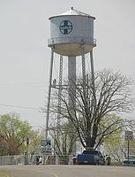
The old Santa Fe water tower in Ash Fork (123 kb) |
|
Bellemont |
||
| Route 66 today follow I-40 for many miles through Arizona. But there are also several places, where you can see the old alignment of Route 66. At Bellemont, between Williams and Flagstaff, you can see some older alignments of Route 66.
From Bellemont you have a nice view over San Francisco Peaks. San Francisco Peaks is a little outside Flafstaff, and is home to the highest point in Arizona, Humphreys Peak (3,851 m / 12,637 feet). San Francisco Peaks is a small volcanic mountain range. |
Route 66 at Bellemont (283 kb) |
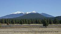
San Francisco Peaks seen from Bellemont (283 kb) |